ARM Group’s New Gravity Meter Enables Advanced Subsurface Imaging for GeoEnvironmental Projects
Knowing what’s underground before you build is critical. ARM’s new Gravity Meter helps uncover what other tools can’t, saving clients time, money, and risk. The Gravity Meter enables us to measure subtle variations in the Earth’s gravitational field, which provides valuable insight to identifying subsurface conditions such as voids, faults, and variations in rock types and depth to rock. With this tool, ARM can provide our clients with a critical edge in site characterization and risk mitigation.
What Is a Gravity Meter?
A Gravity Meter, sometimes referred to as a gravimeter, is an ultra-sensitive instrument used to detect subtle differences in gravity from one point to another. These differences occur due to variations in subsurface mass and density, and ARM’s processing and interpretation of gravity datasets helps us assess subsurface conditions that may otherwise be hidden from view.
In practical terms, this means our Gravity Meter can detect evidence of underground conditions such as:
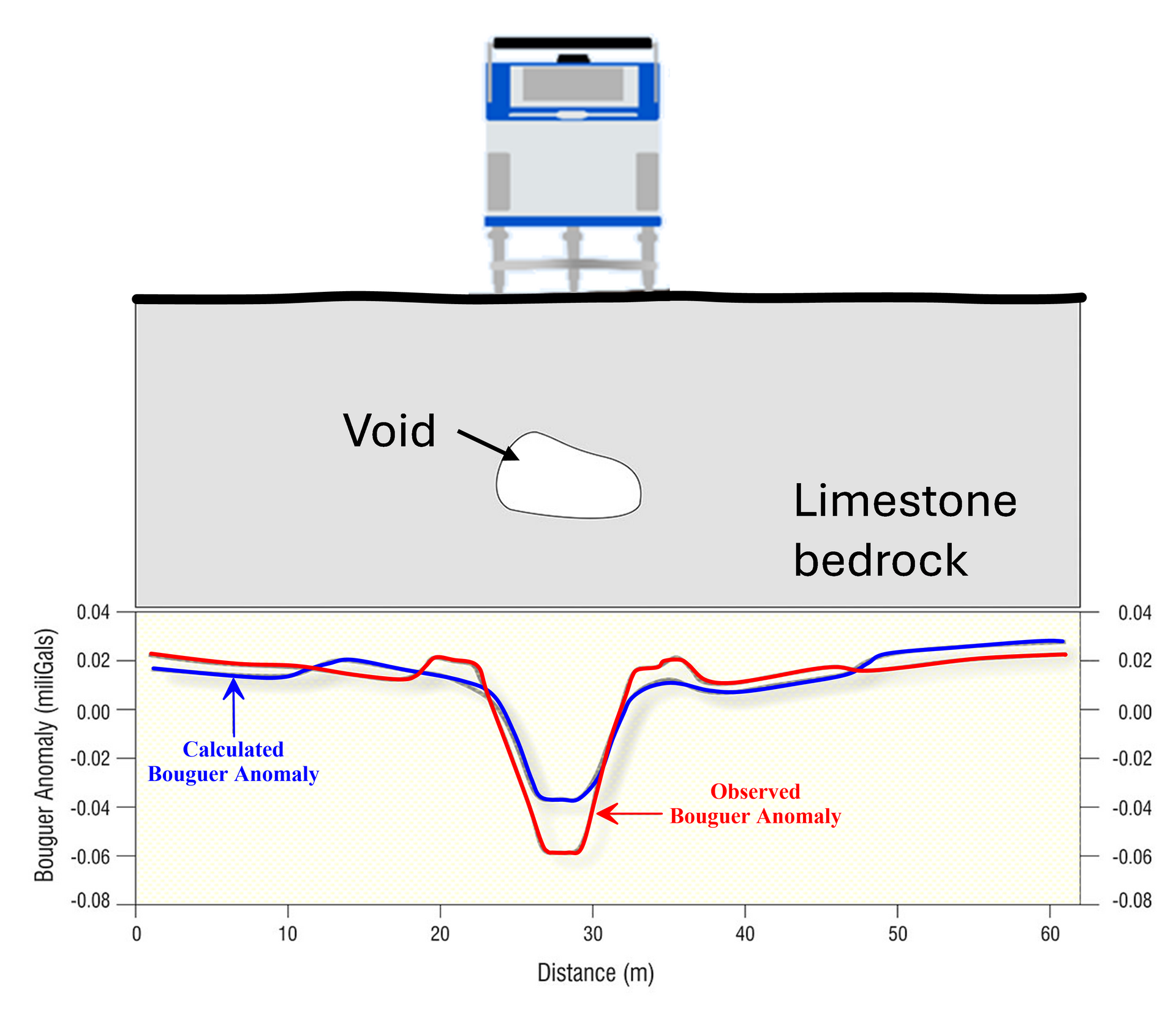
- Sinkholes or voids that pose geotechnical risks
- Buried karst-related features in limestone terrains
- Spatial variations in bedrock elevation
- Fracture zones, fault lines, or related zones of enhanced weathering
- Heavy mineral deposits
The instrument works by measuring gravitational acceleration with extreme accuracy, typically down to microgals (one microgal = one millionth of a gal, where 1 gal = 1 cm/s²). These measurements are then analyzed alongside topographic and geologic data to create detailed models of what lies beneath the surface.
What Can a Gravity Meter Do for Your Projects?
Understanding what lies beneath your site is critical, whether you're planning a major infrastructure build, conducting environmental assessments, or remediating a brownfield. The Gravity Meter helps reduce uncertainty, minimize risk, and avoid costly surprises during excavation or construction.
Key benefits include:
- Non-invasive data collection: Reduce the number of invasive exploration locations.
- Efficient data collection: Gravity surveys are ideal for providing verification of anomalies detected by other geophysical methods and are useful in areas where site conditions may interfere with other geophysical methods.
- Cost-effective early detection: Early identification of subsurface hazards prevents delays and change orders later.
This technology is particularly valuable for:
- Civil infrastructure planning
- Energy and utility projects
- Land development in karst-prone areas
- Environmental and geotechnical investigations and site assessments.
Why ARM Group?
ARM isn’t just one of the few firms with access to advanced gravity meter technology; we’re one of the only ones who pair it with a multidisciplinary team of engineers, geologists, and environmental scientists. Our strength lies in our broad suite of services, from Environmental Site Assessments to geotechnical evaluations and remedial design, ensuring clients get not just information, but a clear path forward.
ARM Group's comprehensive capabilities include:
- High-resolution geophysical surveys
- Geotechnical engineering
- Mine & quarry support
- Water resources development
- Phase I and II Environmental Site Assessments
- Risk-based remediation and regulatory compliance strategies
- Compliance and permitting support and expert services
- Construction-phase and post-development monitoring
Whether you're a developer assessing a brownfield site, a utility evaluating alignment alternatives, or a municipality managing complex subsurface risks, ARM delivers full-spectrum support from discovery through delivery.
Let's Talk
Do you want to learn how a gravity survey and other geophysical methods can strengthen your next project and minimize your potential risks? Get in touch with our geophysics team today. At ARM, we don’t just collect data, we deliver clarity below the surface.
gravity meter blog